
Dosiye:South Korea (orthographic projection).svg

Size of this PNG preview of this SVG file: 541 × 541 pixels. Indi ingano zagutse: 240 × 240 pixels | 480 × 480 pixels | 768 × 768 pixels | 1.024 × 1.024 pixels | 2.048 × 2.048 pixels.
Dosiye nyirizina (SVG file, nominally 541 × 541 pixels, file size: 341 KB)
Incamake
| Umwirondoro |
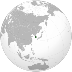
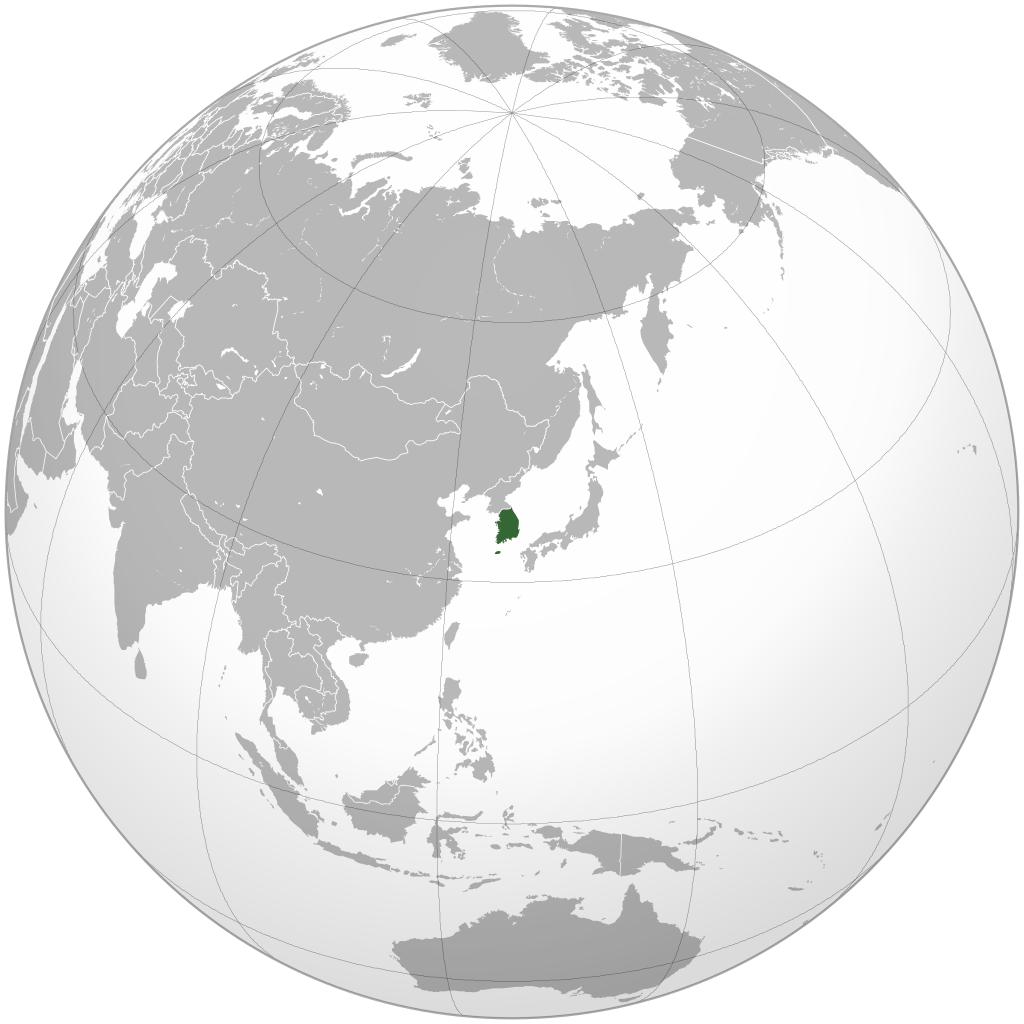
English: Orthographic map of South Korea generated by GMT, editted with Inkscape and Adobe Illustrator.
한국어: 정사도법으로 제작된 남한 지도. GMT로 생성한 후, Inkscape와 Adobe Illustrator로 수정함. |
||
| Itariki | |||
| Inkomoko | Own work by Uploader, colors are from User:Ssolbergj's orthographic map series (see below). | ||
| Umwanditsi | Ksiom | ||
| Other versions |
.svg)
|
.svg)
.svg)
.svg)
.svg)
.svg)
.svg)
.svg)
.svg)
.svg)
.svg)
.svg)
.svg)
.svg)
.svg)
.svg)
.svg)
.svg)
.svg)
.svg)
.svg)
.svg)
.svg)
.svg)
.svg)
.svg)
.svg)
.svg)
.svg)
.svg)
.svg)
.svg)
.svg)
.svg)
.svg)
.svg)
.svg)
.svg)
.svg)
.svg)
.svg)
.svg)
.svg)
.svg)
.svg)
.svg)
.svg)
.svg)
.svg)
.svg)
.svg)
.svg)
.svg)
.svg)
.svg)
.svg)
.svg)
.svg)
.svg)
.svg)
.svg)
.svg)
.svg)
.svg)
.svg)
.svg)
.svg)
.svg)
.svg)
.svg)
.svg)
.svg)
.svg)
.svg)

.svg)

.svg)

.svg)
.svg)
.svg)
.svg)
.svg)
.svg)
.svg)


.svg)
.svg)
.svg)
.svg)
.svg)
.svg)
.svg)

.svg)
.svg)
.svg)
.svg)
.svg)
.svg)
.svg)
.svg)
.svg)
.svg)

.svg)
.svg)
.svg)
.svg)
.svg)
.svg)
.svg)
_without_national_boundaries.svg)
.svg)
.svg)
.svg)
.svg)
.svg)
.svg)

.svg)
.svg)
.png)
.svg)
.svg)
.svg)
.svg)

.svg)
.svg)
.svg)
.svg)
.svg)
.svg)
.svg)
.svg)
.svg)
.svg)
.svg)

.svg)
.svg)
.svg)
.svg)
.svg)
.svg)
.svg)
.svg)
.svg)

.svg)
.svg)

.svg)
.svg)
.svg)
.svg)
.svg)
.svg)
.svg)
.svg)
.svg)
.svg)
.svg)
.svg)
.svg)
.svg)
.svg)
.svg)
.svg)
.svg)
.svg)
.svg)
.svg)
.svg)
.svg)
.svg)
.svg)
.svg)
.svg)
_-_Crimea_disputed.svg)
.svg)
.svg)
.svg)
.svg)
.svg)
.svg)
.svg)
.svg)
.svg)
.svg)
.svg)
_political.svg)
.svg)
.svg)
.svg)
.svg)
_-_Crimea_disputed_-_no_borders.svg)
.svg)
.svg)
.svg)
.svg)
.svg)
.svg)
.svg)
.svg)
.svg)
.svg)
.svg)

.svg)
.svg)
.svg)

.png)
.svg)
.svg)
.svg)
.svg)
.svg)
.svg)
.svg)
.svg)
.svg)
.svg)
.svg)
.svg)
.svg)
.svg)
.svg)
.svg)
.svg)
.svg)
.svg)
.svg)
.svg)
.svg)
.svg)
.svg)
.svg)
.svg)
.svg)
.svg)
.svg)
.svg)
.svg)
.svg)
.svg)
.svg)
.png)
.svg)
.svg)
.svg)
_(orthographic_projection).png)
.svg)
.svg)
.svg)
Uruhushya
I, the copyright holder of this work, hereby publish it under the following licenses:
This file is licensed under the Creative Commons Attribution-Share Alike 3.0 Unported license.
- Ufite umudendezo:
- gusangiza – to copy, distribute and transmit the work
- to remix – gutangira ibikorwa
- Under the following conditions:
- umurimo – You must give appropriate credit, provide a link to the license, and indicate if changes were made. You may do so in any reasonable manner, but not in any way that suggests the licensor endorses you or your use.
- imigabane isa – If you remix, transform, or build upon the material, you must distribute your contributions under the same or compatible license as the original.

|
Permission is granted to copy, distribute and/or modify this document under the terms of the GNU Free Documentation License, Version 1.2 or any later version published by the Free Software Foundation; with no Invariant Sections, no Front-Cover Texts, and no Back-Cover Texts. A copy of the license is included in the section entitled GNU Free Documentation License. |
You may select the license of your choice.
Amateka ya dosiye
Kanda kwitariki/n'isaha kugirango ufungure dosiye nkuko yagaragaye cyagihe.
.svg&dir=prev)
.svg&offset=20090710122643)
.svg&offset=&limit=20)
.svg&offset=&limit=50)
.svg&offset=&limit=100)
.svg&offset=&limit=250)
.svg&offset=&limit=500)
| Itariki/Isaha | Ifoto ntoya | Ibipimo | Umukoresha | Comment | |
|---|---|---|---|---|---|
| muri iki gihe | 06:09, 17 Mata 2022 | | 541 × 541 (341 KB) | ToughDonk | Reverted to version as of 14:58, 21 November 2017 (UTC): Unexplained revert |
| 00:01, 17 Mata 2022 |  | 541 × 541 (345 KB) | Cesar David MP | Reverted to version as of 01:42, 21 August 2017 (UTC) | |
| 14:58, 21 Ugushyingo 2017 |  | 541 × 541 (341 KB) | Sharouser | Reverted to version as of 21:58, 19 August 2017 (UTC) South Korea means the region which is administered by ROK. | |
| 01:42, 21 Kanama 2017 |  | 541 × 541 (345 KB) | Supreme Dragon | Reverted to version as of 20:54, 11 June 2017 (UTC) Please see http://www.law.go.kr/lsInfoP.do?lsiSeq=61603&efYd=19880225#0000 | |
| 21:58, 19 Kanama 2017 |  | 541 × 541 (341 KB) | Crossswords | Reverted to version as of 15:49, 17 November 2012 (UTC) | |
| 20:54, 11 Kamena 2017 |  | 541 × 541 (345 KB) | Supreme Dragon | Added North Korea in light green, which South Korea claims the whole Korea according to the constitution. | |
| 15:49, 17 Ugushyingo 2012 |  | 541 × 541 (341 KB) | Ksiom | Reverted to version as of 15:10, 10 July 2009 | |
| 09:27, 26 Nzeri 2010 |  | 536 × 536 (370 KB) | Valentim | Reverted to version as of 12:26, 10 July 2009. Removing space between projection and edge of this picture. | |
| 15:10, 10 Nyakanga 2009 |  | 541 × 541 (341 KB) | Ksiom | revised version | |
| 12:26, 10 Nyakanga 2009 |  | 536 × 536 (370 KB) | ASDFGHJ | fix top lines problem |
Ikoreshwa rya dosiye
There are no pages that use this file.
Ikoreshwa rya dosiye rusange
Izindi wiki zikurikira zikoresha iyi dosiye:
- Ikoreshwa kuri af.wikipedia.org
- Ikoreshwa kuri ar.wikipedia.org
- قائمة الدول ذات السيادة والأقاليم التابعة في آسيا
- مستخدم:جار الله/قائمة صور مقالات العلاقات الثنائية
- العلاقات الأنغولية الكورية الجنوبية
- العلاقات الإريترية الكورية الجنوبية
- العلاقات السويسرية الكورية الجنوبية
- العلاقات الألمانية الكورية الجنوبية
- العلاقات الكورية الجنوبية الليختنشتانية
- العلاقات البوليفية الكورية الجنوبية
- العلاقات الكورية الجنوبية الموزمبيقية
- العلاقات الألبانية الكورية الجنوبية
- العلاقات البلجيكية الكورية الجنوبية
- العلاقات الإثيوبية الكورية الجنوبية
- العلاقات البيلاروسية الكورية الجنوبية
- العلاقات الطاجيكستانية الكورية الجنوبية
- العلاقات الروسية الكورية الجنوبية
- العلاقات الرومانية الكورية الجنوبية
- العلاقات الأرجنتينية الكورية الجنوبية
- العلاقات الغامبية الكورية الجنوبية
- العلاقات القبرصية الكورية الجنوبية
- العلاقات السيراليونية الكورية الجنوبية
- العلاقات الكورية الجنوبية النيبالية
- العلاقات الكورية الجنوبية الليبيرية
- العلاقات التشيكية الكورية الجنوبية
- العلاقات الكورية الجنوبية الميانمارية
- العلاقات الكندية الكورية الجنوبية
- العلاقات الزيمبابوية الكورية الجنوبية
- العلاقات البالاوية الكورية الجنوبية
- العلاقات الكورية الجنوبية المالية
- العلاقات الكورية الجنوبية النيجيرية
- العلاقات اليمنية الكورية الجنوبية
- العلاقات الفانواتية الكورية الجنوبية
- العلاقات الغابونية الكورية الجنوبية
- العلاقات البنمية الكورية الجنوبية
- العلاقات الكوبية الكورية الجنوبية
- العلاقات الجورجية الكورية الجنوبية
- العلاقات التونسية الكورية الجنوبية
- العلاقات الكورية الجنوبية الكورية الشمالية
- العلاقات الهندية الكورية الجنوبية
- العلاقات الإيطالية الكورية الجنوبية
- العلاقات الكورية الجنوبية الناوروية
- العلاقات الأسترالية الكورية الجنوبية
- العلاقات الزامبية الكورية الجنوبية
- العلاقات الفيجية الكورية الجنوبية
- العلاقات المارشالية الكورية الجنوبية
- العلاقات الأذربيجانية الكورية الجنوبية
- العلاقات السودانية الكورية الجنوبية
- العلاقات الكويتية الكورية الجنوبية
- العلاقات الكونغوية الكورية الجنوبية
- العلاقات الدومينيكانية الكورية الجنوبية
View more global usage of this file.
.svg)
.svg)