
Dosiye:Oceania ISO 3166-1.svg

Size of this PNG preview of this SVG file: 780 × 500 pixels. Indi ingano zagutse: 320 × 205 pixels | 640 × 410 pixels | 1.024 × 656 pixels | 1.280 × 821 pixels | 2.560 × 1.641 pixels.
Dosiye nyirizina (SVG file, nominally 780 × 500 pixels, file size: 146 KB)
Incamake
| Umwirondoro |
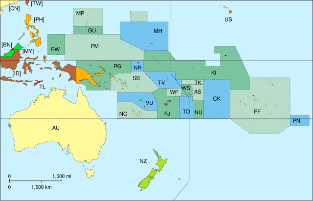
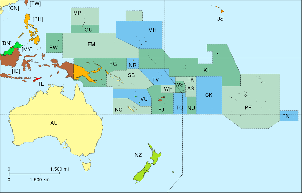
Map of Oceania, with ISO 3166-1 pt · en country and territory code. SVG format. Map legend in Portuguese and English, with name of sovereign state given in parenthesis, where applicable:
On map, but part of Asia:
|
| Itariki | |
| Inkomoko | Own work |
| Umwanditsi | Júlio Reis |
| Other versions |
|


Uruhushya
This file is licensed under the Creative Commons Attribution-Share Alike 3.0 Unported license.
- Ufite umudendezo:
- gusangiza – to copy, distribute and transmit the work
- to remix – gutangira ibikorwa
- Under the following conditions:
- umurimo – You must give appropriate credit, provide a link to the license, and indicate if changes were made. You may do so in any reasonable manner, but not in any way that suggests the licensor endorses you or your use.
- imigabane isa – If you remix, transform, or build upon the material, you must distribute your contributions under the same or compatible license as the original.
derivative works
Derivative works of this file: Oceania blank.svg
Amateka ya dosiye
Kanda kwitariki/n'isaha kugirango ufungure dosiye nkuko yagaragaye cyagihe.
| Itariki/Isaha | Ifoto ntoya | Ibipimo | Umukoresha | Comment | |
|---|---|---|---|---|---|
| muri iki gihe | 17:45, 7 Ugushyingo 2015 | | 780 × 500 (146 KB) | BurritoBazooka | getting rid of transparent border around map |
| 16:50, 25 werurwe 2014 |  | 800 × 520 (145 KB) | Knyaz-1988 | New version | |
| 16:49, 25 werurwe 2014 |  | 800 × 520 (162 KB) | Knyaz-1988 | Reverted to version as of 04:23, 21 December 2007 | |
| 04:24, 21 Ukuboza 2007 |  | 800 × 520 (162 KB) | ButterStick | ||
| 04:23, 21 Ukuboza 2007 |  | 800 × 520 (162 KB) | ButterStick | ||
| 04:21, 21 Ukuboza 2007 |  | 800 × 520 (162 KB) | ButterStick | Code optimization | |
| 13:35, 30 Gicurasi 2006 |  | 800 × 520 (238 KB) | Tintazul | {{Tintazul| |Description=Map of Oceania, with ISO 3166-1 <sup>pt · en</sup> country and territory code. SVG format. Map legend in Portuguese and English, with name of sovereign state given in parenthesis, where appl |
Ikoreshwa rya dosiye
Ibi bikurikira abakoresha urupapuro iyi dosiye:
Ikoreshwa rya dosiye rusange
Izindi wiki zikurikira zikoresha iyi dosiye:
- Ikoreshwa kuri ace.wikipedia.org
- Ikoreshwa kuri ar.wikipedia.org
- Ikoreshwa kuri as.wikipedia.org
- Ikoreshwa kuri bat-smg.wikipedia.org
- Ikoreshwa kuri cs.wikipedia.org
- Ikoreshwa kuri de.wikipedia.org
- Ikoreshwa kuri de.wiktionary.org
- Ikoreshwa kuri diq.wikipedia.org
- Ikoreshwa kuri en.wikipedia.org
- Ikoreshwa kuri es.wikipedia.org
- Ikoreshwa kuri et.wikipedia.org
- Ikoreshwa kuri fa.wikipedia.org
- Ikoreshwa kuri gd.wikipedia.org
- Ikoreshwa kuri gl.wikipedia.org
- Ikoreshwa kuri gl.wikiquote.org
- Ikoreshwa kuri ia.wikipedia.org
View more global usage of this file.