
Dosiye:Map of Lebanon.png
No higher resolution available.
Map_of_Lebanon.png (325 × 349 pixels, file size: 10 KB, MIME type: image/png)
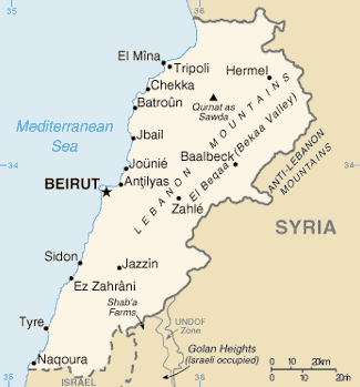
Map of Lebanon from de wiki/CIA World Factbook. Attribution note: this image's update on 2010-09-23 was originally done by Shimgray at English Wikipedia.
This image is in the public domain because it contains materials that originally came from the United States Central Intelligence Agency's World Factbook.
|
 |
Amateka ya dosiye
Kanda kwitariki/n'isaha kugirango ufungure dosiye nkuko yagaragaye cyagihe.
| Itariki/Isaha | Ifoto ntoya | Ibipimo | Umukoresha | Comment | |
|---|---|---|---|---|---|
| muri iki gihe | 01:24, 2 Nyakanga 2012 | | 325 × 349 (10 KB) | Ras67 | cropped |
| 09:31, 23 Nzeri 2010 |  | 330 × 354 (10 KB) | Rehman | updated file from English Wikipedia | |
| 13:25, 6 werurwe 2005 |  | 330 × 354 (10 KB) | Carlosar~commonswiki | Map of Lebanon from de wiki (http://de.wikipedia.org/upload/8/85/Libanon.png)/CIA World Factbook. |
Ikoreshwa rya dosiye
Ibi bikurikira abakoresha urupapuro iyi dosiye:
Ikoreshwa rya dosiye rusange
Izindi wiki zikurikira zikoresha iyi dosiye:
- Ikoreshwa kuri af.wikipedia.org
- Ikoreshwa kuri ang.wikipedia.org
- Ikoreshwa kuri arz.wikipedia.org
- Ikoreshwa kuri ast.wikipedia.org
- Ikoreshwa kuri as.wikipedia.org
- Ikoreshwa kuri azb.wikipedia.org
- Ikoreshwa kuri ban.wikipedia.org
- Ikoreshwa kuri bcl.wikipedia.org
- Ikoreshwa kuri bg.wikipedia.org
- Ikoreshwa kuri ca.wikipedia.org
- Ikoreshwa kuri ceb.wikipedia.org
- Ikoreshwa kuri ckb.wikipedia.org
- Ikoreshwa kuri cs.wikipedia.org
- Ikoreshwa kuri da.wikipedia.org
- Ikoreshwa kuri de.wikinews.org
- Ikoreshwa kuri diq.wikipedia.org
- Ikoreshwa kuri dsb.wikipedia.org
- Ikoreshwa kuri el.wikipedia.org
- Ikoreshwa kuri en.wikipedia.org
- Geography of Lebanon
- Wikipedia talk:In the news/Archive 8
- 2008 Tripoli, Lebanon bombings
- United Nations Security Council Resolution 436
- United Nations Security Council Resolution 509
- United Nations Security Council Resolution 564
- United Nations Security Council Resolution 1095
- Category:Populated places in Lebanon
- Energy in Lebanon
- Geothermal energy in Lebanon
- Ikoreshwa kuri en.wikinews.org
- Ikoreshwa kuri eo.wikipedia.org
- Ikoreshwa kuri es.wikipedia.org
- Ikoreshwa kuri es.wikibooks.org
- Ikoreshwa kuri eu.wikipedia.org
- Ikoreshwa kuri ext.wikipedia.org
- Ikoreshwa kuri fa.wikipedia.org
View more global usage of this file.