
Dosiye:Maldives - Kurumba Island.jpg

Ingano yiri shusho:800 × 600 pixels. Indi ingano zagutse: 320 × 240 pixels | 640 × 480 pixels | 1.024 × 768 pixels.
Dosiye nyirizina (1.024 × 768 pixels, file size: 95 KB, MIME type: image/jpeg)
Incamake
| Umwirondoro |
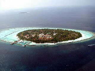
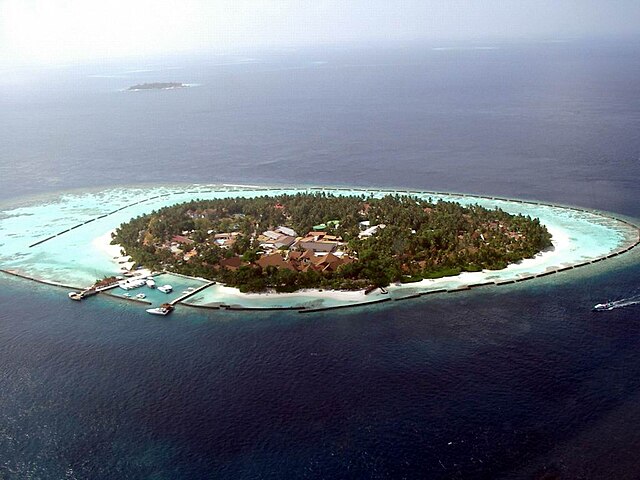
English: Aerial view of Kurumba Island in the Maldives |
| Itariki | |
| Inkomoko | Own work |
| Umwanditsi | PalawanOz |
| Camera location | | View this and other nearby images on: OpenStreetMap |
|---|
Uruhushya
| I, the copyright holder of this work, release this work into the public domain. This applies worldwide. In some countries this may not be legally possible; if so: I grant anyone the right to use this work for any purpose, without any conditions, unless such conditions are required by law. |
Amateka ya dosiye
Kanda kwitariki/n'isaha kugirango ufungure dosiye nkuko yagaragaye cyagihe.
| Itariki/Isaha | Ifoto ntoya | Ibipimo | Umukoresha | Comment | |
|---|---|---|---|---|---|
| muri iki gihe | 11:35, 16 Ugushyingo 2008 | | 1.024 × 768 (95 KB) | PalawanOz | {{Information |Description={{en|1=Aerial view of Kurumba Island in the Maldives}} |Source=Own work by uploader |Author=PalawanOz |Date=2003 |Permission= |other_versions= }} {{Coor dms|4|16|9.6|N|73|29|40.3|E}} <!--{{ImageUpload|full}}-- |
Ikoreshwa rya dosiye
Ibi bikurikira abakoresha urupapuro iyi dosiye:
Ikoreshwa rya dosiye rusange
Izindi wiki zikurikira zikoresha iyi dosiye:
- Ikoreshwa kuri af.wikipedia.org
- Ikoreshwa kuri ar.wikipedia.org
- Ikoreshwa kuri ast.wikipedia.org
- Ikoreshwa kuri de.wikipedia.org
- Ikoreshwa kuri de.wikivoyage.org
- Ikoreshwa kuri en.wikipedia.org
- Ikoreshwa kuri es.wikipedia.org
- Ikoreshwa kuri eu.wikipedia.org
- Ikoreshwa kuri fr.wikipedia.org
- Ikoreshwa kuri gu.wikipedia.org
- Ikoreshwa kuri it.wikipedia.org
- Ikoreshwa kuri kn.wikipedia.org
- Ikoreshwa kuri la.wikipedia.org
- Ikoreshwa kuri no.wikipedia.org
- Ikoreshwa kuri ru.wikipedia.org
- Ikoreshwa kuri ta.wikipedia.org
- Ikoreshwa kuri tr.wikipedia.org
- Ikoreshwa kuri vi.wikipedia.org
- Ikoreshwa kuri www.wikidata.org
- Ikoreshwa kuri zh.wikipedia.org