
Dosiye:Princes Islands.png

Ingano yiri shusho:741 × 600 pixels. Indi ingano zagutse: 297 × 240 pixels | 593 × 480 pixels | 777 × 629 pixels.
Dosiye nyirizina (777 × 629 pixels, file size: 1,01 MB, MIME type: image/png)
Incamake
| Umwirondoro |
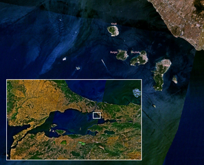
Ελληνικά: Δορυφορική φωτογραφία των Πριγκηπονησίων, Θάλασσα του Μαρμαρά |
| Inkomoko | Own work |
| Umwanditsi | Duja |
Source
Own work, based on public-domain en:Landsat imagery using en:NASA WorldWind.
Author
Uruhushya
I, the copyright holder of this work, hereby publish it under the following licenses:

|
Permission is granted to copy, distribute and/or modify this document under the terms of the GNU Free Documentation License, Version 1.2 or any later version published by the Free Software Foundation; with no Invariant Sections, no Front-Cover Texts, and no Back-Cover Texts. A copy of the license is included in the section entitled GNU Free Documentation License. |
| This file is licensed under the Creative Commons Attribution-Share Alike 3.0 Unported license. | ||
| ||
| This licensing tag was added to this file as part of the GFDL licensing update. |
You may select the license of your choice.
| This image is in the public domain because it is a screenshot from NASA’s globe software World Wind using a public domain layer, such as Blue Marble, MODIS, Landsat, SRTM, USGS or GLOBE.
|
 |
Amateka ya dosiye
Kanda kwitariki/n'isaha kugirango ufungure dosiye nkuko yagaragaye cyagihe.
| Itariki/Isaha | Ifoto ntoya | Ibipimo | Umukoresha | Comment | |
|---|---|---|---|---|---|
| muri iki gihe | 09:38, 19 Gashyantare 2007 | | 777 × 629 (1,01 MB) | Duja | |
| 09:29, 19 Gashyantare 2007 |  | 777 × 629 (1,02 MB) | Duja | ==Description== Satellite map of en:Princes' Islands, with a wider map of en:Sea of Marmara ==Source== Own work, based on public-domain Landsat imagery using NASA WorldWind. ==Author== User:Duja ==License== {{GFDL-self}} [[Catego |
Ikoreshwa rya dosiye
Ibi bikurikira abakoresha urupapuro iyi dosiye:
Ikoreshwa rya dosiye rusange
Izindi wiki zikurikira zikoresha iyi dosiye:
- Ikoreshwa kuri az.wikipedia.org
- Ikoreshwa kuri bg.wikipedia.org
- Ikoreshwa kuri ca.wikipedia.org
- Ikoreshwa kuri ceb.wikipedia.org
- Ikoreshwa kuri ce.wikipedia.org
- Ikoreshwa kuri cs.wikipedia.org
- Ikoreshwa kuri de.wikivoyage.org
- Ikoreshwa kuri diq.wikipedia.org
- Ikoreshwa kuri el.wikipedia.org
- Ikoreshwa kuri en.wikipedia.org
- Ikoreshwa kuri eo.wikipedia.org
- Ikoreshwa kuri es.wikipedia.org
- Ikoreshwa kuri fi.wikipedia.org
- Ikoreshwa kuri fr.wikipedia.org
- Ikoreshwa kuri gl.wikipedia.org
- Ikoreshwa kuri he.wikipedia.org
- Ikoreshwa kuri he.wikivoyage.org
- Ikoreshwa kuri hy.wikipedia.org
- Ikoreshwa kuri id.wikipedia.org
- Ikoreshwa kuri it.wikipedia.org
- Ikoreshwa kuri ka.wikipedia.org
- Ikoreshwa kuri ko.wikipedia.org
- Ikoreshwa kuri mk.wikipedia.org
- Ikoreshwa kuri mrj.wikipedia.org
- Ikoreshwa kuri nn.wikipedia.org
- Ikoreshwa kuri pl.wikipedia.org
View more global usage of this file.