
Dosiye:LocationAnguilla.png
No higher resolution available.
LocationAnguilla.png (250 × 115 pixels, file size: 5 KB, MIME type: image/png)
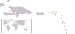
Country locator map - Anguilla
This country locator map was created by Vardion and is released into the public domain.
| This work has been released into the public domain by its author, Vardion at Icyongereza Wikipediya. This applies worldwide. In some countries this may not be legally possible; if so: Vardion grants anyone the right to use this work for any purpose, without any conditions, unless such conditions are required by law. |
Amateka ya dosiye
Kanda kwitariki/n'isaha kugirango ufungure dosiye nkuko yagaragaye cyagihe.
| Itariki/Isaha | Ifoto ntoya | Ibipimo | Umukoresha | Comment | |
|---|---|---|---|---|---|
| muri iki gihe | 11:09, 14 Gashyantare 2005 | | 250 × 115 (5 KB) | Knutux | Country locator map - Anguilla |
Ikoreshwa rya dosiye
Ibi bikurikira abakoresha urupapuro iyi dosiye:
Ikoreshwa rya dosiye rusange
Izindi wiki zikurikira zikoresha iyi dosiye:
- Ikoreshwa kuri ar.wikipedia.org
- Ikoreshwa kuri arz.wikipedia.org
- Ikoreshwa kuri azb.wikipedia.org
- Ikoreshwa kuri az.wiktionary.org
- Ikoreshwa kuri ba.wikipedia.org
- Ikoreshwa kuri be-tarask.wikipedia.org
- Ikoreshwa kuri be.wikipedia.org
- Ikoreshwa kuri bg.wikipedia.org
- Ikoreshwa kuri bpy.wikipedia.org
- Ikoreshwa kuri bs.wikipedia.org
- Ikoreshwa kuri chr.wikipedia.org
- Ikoreshwa kuri de.wikivoyage.org
- Ikoreshwa kuri de.wiktionary.org
- Ikoreshwa kuri dsb.wikipedia.org
- Ikoreshwa kuri el.wikipedia.org
- Ikoreshwa kuri en.wikipedia.org
- Ikoreshwa kuri en.wikivoyage.org
- Ikoreshwa kuri eo.wikipedia.org
- Ikoreshwa kuri fi.wikivoyage.org
- Ikoreshwa kuri fr.wiktionary.org
- Ikoreshwa kuri he.wikivoyage.org
- Ikoreshwa kuri hr.wikipedia.org
- Ikoreshwa kuri hu.wikipedia.org
- Ikoreshwa kuri hu.wikinews.org
- Ikoreshwa kuri ilo.wikipedia.org
- Ikoreshwa kuri incubator.wikimedia.org
- Ikoreshwa kuri it.wikivoyage.org
- Ikoreshwa kuri jam.wikipedia.org
- Ikoreshwa kuri ja.wikipedia.org
- Ikoreshwa kuri jv.wikipedia.org
- Ikoreshwa kuri ka.wikipedia.org
- Ikoreshwa kuri ko.wiktionary.org
- Ikoreshwa kuri kw.wikipedia.org
- Ikoreshwa kuri lij.wikipedia.org
- Ikoreshwa kuri li.wikipedia.org
- Ikoreshwa kuri lmo.wikipedia.org
- Ikoreshwa kuri lt.wikipedia.org
- Ikoreshwa kuri lt.wiktionary.org
- Ikoreshwa kuri lv.wikipedia.org
- Ikoreshwa kuri mk.wikipedia.org
View more global usage of this file.