
Dosiye:Kasai River Catchment OSM.png

Ingano yiri shusho:500 × 600 pixels. Indi ingano zagutse: 200 × 240 pixels | 400 × 480 pixels | 640 × 768 pixels | 853 × 1.024 pixels | 1.577 × 1.892 pixels.
Dosiye nyirizina (1.577 × 1.892 pixels, file size: 5,12 MB, MIME type: image/png)
Incamake
| Umwirondoro |
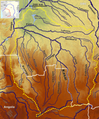
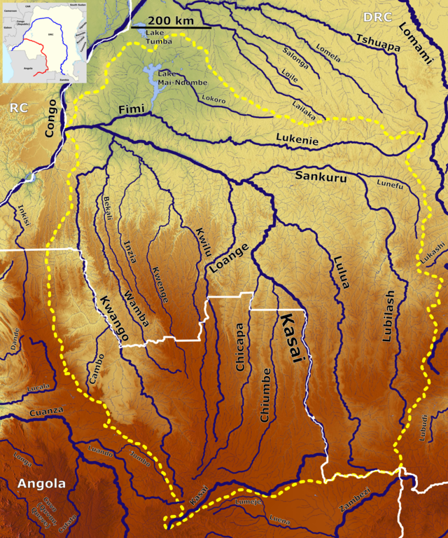
English: The Kasai catchment OSM, Based up on US Army map SC34 - SB34 |
| Itariki | |
| Inkomoko | https://maps-for-free.com, https://maps.lib.utexas.edu/maps/imw/, Location map:https://commons.wikimedia.org/wiki/File:Democratic_Republic_of_the_Congo_adm_location_map.svg |
| Umwanditsi | Hans Braxmeier & Peter in s, Location map:NordNordWest |
This file is licensed under the Creative Commons Attribution-Share Alike 3.0 Unported license.
- Ufite umudendezo:
- gusangiza – to copy, distribute and transmit the work
- to remix – gutangira ibikorwa
- Under the following conditions:
- umurimo – You must give appropriate credit, provide a link to the license, and indicate if changes were made. You may do so in any reasonable manner, but not in any way that suggests the licensor endorses you or your use.
- imigabane isa – If you remix, transform, or build upon the material, you must distribute your contributions under the same or compatible license as the original.
Amateka ya dosiye
Kanda kwitariki/n'isaha kugirango ufungure dosiye nkuko yagaragaye cyagihe.
| Itariki/Isaha | Ifoto ntoya | Ibipimo | Umukoresha | Comment | |
|---|---|---|---|---|---|
| muri iki gihe | 11:05, 3 Kamena 2022 | | 1.577 × 1.892 (5,12 MB) | Peter in s | Kontrast, Lokation,... |
| 04:15, 11 werurwe 2020 |  | 1.577 × 1.892 (5,27 MB) | Peter in s | + Location | |
| 20:08, 10 werurwe 2020 |  | 1.577 × 1.892 (5,5 MB) | Peter in s | {{Information |description ={{en|1=The Kasai catchment OSM}} |date =2020-03-10 |source =https://maps-for-free.com |author =Hans Braxmeier & Peter in s }} {{cc-by-sa-2.0}} Category:Maps of rivers of Angola Category:Maps of rivers of the Democratic Republic of the Congo Category:Kasai River Basin |
Ikoreshwa rya dosiye
Ibi bikurikira 3 imikoreshereze yarwo iyi dosiye:
Ikoreshwa rya dosiye rusange
Izindi wiki zikurikira zikoresha iyi dosiye:
- Ikoreshwa kuri arz.wikipedia.org
- Ikoreshwa kuri bg.wikipedia.org
- Ikoreshwa kuri de.wikipedia.org
- Ikoreshwa kuri en.wikipedia.org
- Ikoreshwa kuri es.wikipedia.org
- Ikoreshwa kuri fr.wikipedia.org
- Ikoreshwa kuri ha.wikipedia.org
- Ikoreshwa kuri lt.wikipedia.org
- Ikoreshwa kuri pt.wikipedia.org
- Ikoreshwa kuri sv.wikipedia.org
- Ikoreshwa kuri xmf.wikipedia.org
- Ikoreshwa kuri zh.wikipedia.org