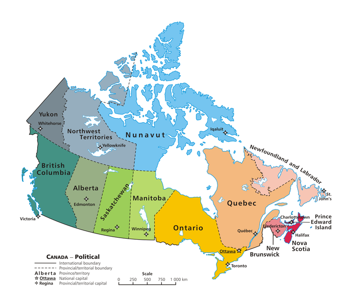
Dosiye:Political map of Canada.png

Ingano yiri shusho:693 × 599 pixels. Indi ingano zagutse: 278 × 240 pixels | 555 × 480 pixels | 888 × 768 pixels | 1.184 × 1.024 pixels | 1.280 × 1.107 pixels.
Dosiye nyirizina (1.280 × 1.107 pixels, file size: 245 KB, MIME type: image/png)
Amateka ya dosiye
Kanda kwitariki/n'isaha kugirango ufungure dosiye nkuko yagaragaye cyagihe.
| Itariki/Isaha | Ifoto ntoya | Ibipimo | Umukoresha | Comment | |
|---|---|---|---|---|---|
| muri iki gihe | 02:50, 13 Kamena 2007 |  | 1.280 × 1.107 (245 KB) | Andrew pmk~commonswiki | optimize png |
| 01:38, 6 Kamena 2007 |  | 1.280 × 1.107 (245 KB) | Andrew pmk~commonswiki | optimize png | |
| 09:35, 6 Kamena 2006 |  | 1.280 × 1.107 (296 KB) | Kaveh | == Summary == Canada: political map – depicting |provinces/territories and capital cities. Drawn and adapted by E Pluribus Anthony from [http://atlas.gc.ca/site/english/maps/reference/national/can_political_e Atlas |
Ikoreshwa rya dosiye
Ibi bikurikira abakoresha urupapuro iyi dosiye:
Ikoreshwa rya dosiye rusange
Izindi wiki zikurikira zikoresha iyi dosiye:
- Ikoreshwa kuri af.wikipedia.org
- Ikoreshwa kuri an.wikipedia.org
- Ikoreshwa kuri arc.wikipedia.org
- Ikoreshwa kuri azb.wikipedia.org
- کانادا
- مونترئال
- کلگری
- برولینگتون، اونتاریو
- اوکویل
- ریچموند هیل، اونتاریو
- ریچموند، بریتیش کولومبیا
- وینزر، اونتاریو
- کیچنر
- ساسکاتون
- بورنابی
- لونگوی
- گاتینو
- وان (کانادا)
- مارکام، اونتاریو
- لاوال، کبئک
- سوری، بریتیش کولومبیا
- همیلتون، اونتاریو
- برمپتون، اونتاریو
- ونکوور
- میسیساگا
- بلویل، اونتاریو
- دولار-ده-اورمو
- شاوینیگان
- سارنیا
- کاوارتا لیکس
- سو سنتماری
- میپل ریج
- چیلیوک
- پیتربورو، اونتاریو
- بروسارد
- نیومارکت، اونتاریو
- رپانتینی، کبئک
- نیاگارا فالز، اونتاریو
- لثبریج
- نانایمو
- میلتون
- قوزئی ونکوور
- کلارینگتون
- کملوپس
- سن-ژان-سور-ریشولیو
- استراثکونا
- برنتفورد، اونتاریو
- کئیپ برتون
- واترلو، اونتاریو
- دلتا، بریتیش کولومبیا
- چاتهام-کنت، اونتاریو
View more global usage of this file.


